
Interactive map of existing and potential greenways in Metro Boston
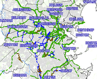
The Metro-Boston Greenways map presents a vision for a greenway network from the Middlesex Fells (north) to the Blue Hills (south), and west to Route 128.
Map size (on the right, under "KeyMap"): choose a size that fits your screen.
Legend: Choose the greenways you wish to see displayed.
- "Paths" are physically separated from traffic.
- "Road" are greenway routes on calm streets with low traffic stress.
- "Proposed" routes have been proven feasible in preliminary studies. They may or may not be actively under consideration by municipalities. Some have a web site where you can find more information.
- "Rough paths" are soft-paved, unpaved, poorly paved, or overly narrow.
Area: Use the dropdown menu to choose a predefined area. Or use the radio buttons on the right to zoom and re-center to any subarea you want.
Information: with the "i" radio button selected, clicking on a link or town generates an information panel below the map.
The Metro-Boston Greenways map is a project of Northeastern University, with support from the National Science Foundation and the Solomon Fund, and help from many people. Use the comment form to suggest corrections or more information.