
Seismic hazard mitigation in the northeastern United States , and especially in New England , continues to receive increasing attention. The historic seismicity record of New England dates back to the mid 1700s and confirms the seismic vulnerability of the region. In 1755 an earthquake occurred off Cape Ann , 40 kilometers northeast of Boston that caused significant damage in the Boston area. The Modified Mercalli Intensity (MMI) of the event has been estimated to be about VIII in Boston . Since then the region has experienced many smaller earthquakes.
The Saguenay earthquake of 1988, in eastern Canada , provided a rare opportunity to record and analyze the characteristics of moderate earthquake ground motions in Eastern North America , (ENA). In the absence of identifiable active faults and known offsets, the seismo-tectonics of the region is not well understood. However, a number of general observations have been made from the limited seismicity data and the few ground motion records available. It appears that ground motions in the ENA attenuate slower than in the Western North America , (WNA). Also, rock motions in ENA compared with typical rock motions in WNA show higher energy in the high frequency range (10-40 Hz), and lower energy in the lower frequency range (0.5-1 Hz).
Because of the historic seismic activity, New England building codes now incorporate requirements for seismic design. Bridges and other critical facilities must meet seismic design guidelines set forth by governing federal and local agencies even though such seismic guidelines are typically based on national codes. New England is now faced with an urgent need to develop reliable seismic design guidelines. These guidelines should be based on a more current understanding of the seismo-tectonics of the region and of the influence of geologic and local site conditions on ground motions. To achieve this goal, it is imperative that we obtain quality ground motion records of future regional earthquakes.
In 1998, Northeastern University was given an opportunity by generous Civil and Environmental Engineering alumni to develop a unique facility that would support our educational and research activities in Earthquake Engineering. With their financial support a seismic recording station was conceived and established to specifically meet the following goals:
- To gather and disseminate valuable seismic ground motion data from smaller, less frequent, moderate earthquakes in the region.
- To improve our understanding of region specific ground motion attenuation and frequency characteristics of seismic motions.
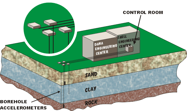
- To understand the effects of deep clay deposits on ground motions and to determine the in-situ shear wave velocity of the Boston Blue Clay. This information will be useful in the preparation of microzonation maps.
- To investigate the soil-structure interaction effects on structures founded on deep deposits of clay.
- To support our educational and research programs in earthquake engineering.
- To heighten the earthquake awareness of both the regional professional and public communities.
- To educate and stir interest of K-12 students in the field of engineering.